Geography & Nations
in NehwonThe lands of this world. Mountains, Rivers, Valleys, Cities, Nations and Landmarks.
World Codex
Maps
-
Lankhmar
The City of Lankhmar. On the Sewer Network layer, all Marker groups don't quite align with the buildings they mark on the base layer map due to a slight shift in scanning. Because of this, it is recommended to uncheck all marker groups when viewing Lankhmar on the Sewer Network Level, or to at least note that there's a slight shift. -
Ool Hrusp
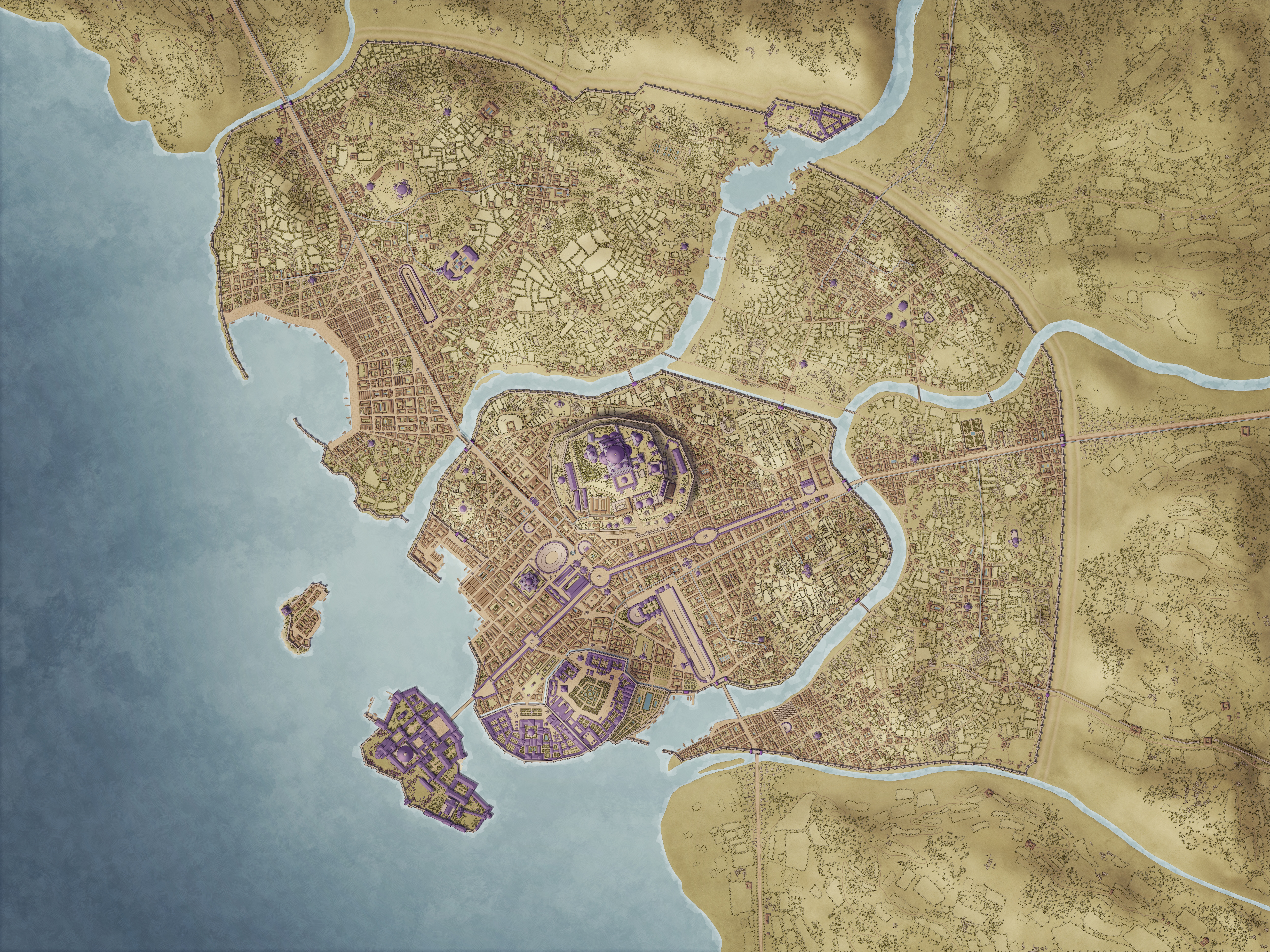
Ool Hrusp is one of the smaller of the famed Eight Cities of Nehwon, yet it thrives as an important trade and livestock hub. Situated on twin peninsulas that form a sheltered natural harbor, the city is a lively blend of sea trade and cattle commerce. The air is thick with the scent of salt and livestock, and the streets bustle with drovers, sailors, and merchants. The city is best known for its vast herds of cattle, which feed the meat and leather trade across the Inner Sea, and for its ruler, Duke Lithquil, whose erratic behavior has earned him the moniker the Mad Duke. His reign oscillates between lavish eccentricity and shrewd pragmatism, and despite his capricious edicts, Ool Hrusp remains prosperous. Geography and Layout North Peninsula – Old City The oldest and most densely populated district, home to major guild halls, and the Grand Harbor Quays where the cattle and leather trade converge. Narrow cobbled streets wind between tall tenements, workshops, and dockside taverns. Lower Peninsula – New City This district holds merchant villas, small lakes, and open parade grounds, as well as tallow works and hide-curing sheds. The harbor here handles bulk shipments of livestock and processed goods. East District A semi-rural urban area with granaries, caravan yards, and small temples. It serves as the entry point for seasonal cattle drives from the plains and surrounding countryside. Harbor Rock A fortified island at the harbor’s mouth, manned by marines and signalmen. Its beacon fire guides ships to safety and deters raiders. Culture and Society Life in Ool Hrusp revolves around livestock and the sea. The Mad Duke Lithquil Lithquil is known for his moonlit banquets, bizarre taxes, and public antics, including dressing favored oxen in silks. Despite his eccentricity, he is astute enough to maintain the city’s prosperity, balancing guild power and rural wealth. Guilds and Trade The Drovers’ Guild and Butchers’ Guild control the cattle market, while the Harbor Guild manages the flow of goods. Trade is brisk and pragmatic; bribes and quiet arrangements ensure that both legal and gray-market goods move efficiently. Religion Ool Hrusp’s people pay homage to Baroom, Lord of Harbors, and to local pastoral spirits tied to cattle and fertility. Roadside shrines decorated with ox horns are a common sight. Economy and Exports The city’s prosperity is rooted in cattle and cattle products: Primary Exports: Live cattle, hides, leather, tallow, salted beef Secondary Exports: Spices, fabrics, and tools from eastern caravans The harbors constantly bustle with barges loaded with livestock, the sounds of lowing cattle blending with the creak of ships and calls of gulls. Atmosphere Ool Hrusp is a city of earthy scents and constant motion. The braying of oxen, the shouts of drovers, and the clanging of harbor cranes create its daily music. At night, the Piers of Painted Lanterns glow across the water, signaling that the city never truly sleeps. Adventure Hooks The Duke’s Feast: An invitation to one of Lithquil’s eccentric midnight banquets draws the party into intrigue and absurdity. The Vanishing Herds: Entire herds disappear from the surrounding plains, with whispers of bandits, cultists, or worse. Smuggler’s Ledger: A missing ledger of illicit cattle shipments and bribes threatens guild stability. The Ghost of Harbor Rock: Sailors report a spectral ox walking the island fortress at night, bellowing before storms. Banner of Duke Lithquil: This is the sigil of Ool Hrusp’s Mad Duke: a golden ox head on a red field, symbolizing the city’s wealth in cattle and the Duke’s eccentric pride. -
M'Brell


